COSO PETROGLYPH LANDMARK: ARCHAEOLOGY, ETHNOGRAPHY,
AND ROCK ART
INTRODUCTION
Little Petroglyph Canyon, in the Coso district, represents one of the most outstanding and best preserved displays of Native American rock art in the country. Most of the images are in a distinct and well-recognized style, known as Coso, although images showing similarities to Mojave Desert and Great Basin styles, and even Southwestern styles, are present as well.
The Coso area has been occupied for millennia by Native American groups, and archaeological sites abound, although there are none in the canyon itself. In prehistoric times the region was inhabited by the Panamint (or Koso) Shoshone, and the current Native American groups are of Paiute-Shoshone descent. Ranching and mining took place in the area beginning in the 1860s, bringing Euro-American people into the Cosos. The Navy assumed management of the area in 1943, at the height of World War II, and the site currently lies within Navy property. The Navy has exercised careful and prudent stewardship of the area, which has ensured the excellent preservation of the petroglyphs as we see them today.
GEOLOGY
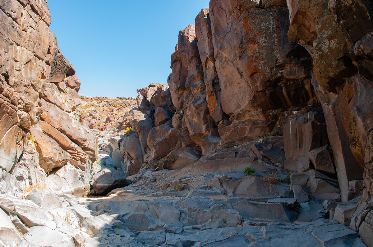
Little Petroglyph Canyon, also known as Renegade Canyon, is located on a high plateau (5,000 feet) in a geologically active area at the eastern edge of the Coso mountain range. The Coso Range lies at the western edge of the Basin and Range geomorphic area. It contains pre-Cenezoic intrusive igneous and metamorphic basement rocks overlain by late Cenezoic volcanic rocks. The volcanic rocks were extruded in two phases, the first from 4 to 2.5 million years ago and the more recent from 1 million years ago to about 30 thousand years ago.
The Coso volcanic field, between Little Petroglyph Canyon and the Sierra Nevada to the west, has been the source of flows of the basaltic lava in which the Coso petroglyphs are carved. Several distinct flows are recognized by geologists. These flows created the visible geological features of the area, including the towering basalt walls of the canyons. As a point of interest, the Coso Mountains, long known for their hot springs and obsidian, are today a source of geothermal power.
Obsidian is evident throughout the Little Petroglyph area, but does not occur naturally there. The primary obsidian source lies in the Coso volcanic field northwest of the canyon. Numerous prehistoric obsidian quarries are located there, with major ones at South Sugarloaf, West Sugarloaf, Cactus Peak, and Joshua Ridge. The obsidian was first quarried sometime in the Lake Mohave Period (12,000 – 7,000 BP), and into the Early Archaic Period (7,000 – 4,000 BP). During the Late Archaic Period (beginning around 4,000 BP) quarry activity moved to Sugarloaf proper and continued through the Rose Spring Period (1,500 – 800 BP). For reasons which are unknown, quarrying stopped about 800 BP and was not resumed. Much of the obsidian was worked into tools and weapons at the foot of the Sierra Nevada, probably for trade, and thick deposits of obsidian waste flakes from tool-making can be seen there. Obsidian flakes found in Little Petroglyph Canyon were probably deposited by run-off water, carried from habitation sites higher up, although some may be the result of on-site reworking of tools by ancient Native Americans.
HYDROLOGY AND CLIMATE
The desert is an arid area, and humans typically cannot survive without water. However, the climate has not always been the same as today, and, in fact, significant climatic changes have occurred in the past. During the Pleistocene, > 12,000 years ago, the Sierra Nevada were heavily glaciated, and Indian Wells Valley was a major lake, Lake China. Pleistocene animals, including sloths and mammoths, lived around it. Somewhat later, Paleoindians occupied the lake margins, and left evidence of their camps and tools. The lakes dried in a major warming about 10,000 BP (BP = before present).
A period of cooler and wetter climate occurred about 4,000 BP, known as the Neo-Glacial. Glaciers returned to the Sierra Nevada, and it is likely that the Coso region had more springs and foliage
than today. Indian Wells Valley probably supported wetlands at this time, and game was more plentiful than in the drier intervals. This productive interval persisted until about 1,200 BP, and probably coincides with a time of population growth and maximum production of Coso rock art.
The Medieval Climatic Anomaly, or MCA, occurred from 1,200 BP to 700 BP. Tree-ring data have established that a significant climatic change occurred about this time, which may have affected settlement and subsistence patterns. Before 1,200 BP, the climate was primarily cool and moist, the end of the Neo-Glacial. From 1,200 to 950 BP the climate was cool and dry, followed by a warm and wet interval until 850 BP. From 850 to 700 BP the climate was very warm and dry, warmer and dryer than today. Modern climate is assumed to have prevailed post 700 BP, with fluctuations.
Settlement patterns in this area must always be understood in the context of such climatic change, since the climate in the period from 4,000 to 1,200 BP led to a very productive landscape, while the climate from 850 – 700 BP may have rendered certain desert areas uninhabitable.
ETHNOGRAPHY/ARCHAEOLOGY
The Paiute-Shoshone peoples of the Death Valley – Owens Valley believe their forebears have always inhabited this area. There is general agreement among scholars that the Paiute-Shoshone peoples have been here at least 600 – 800 years (considerably longer than the United States has existed!). Prior to that there is disagreement, with two primary views, one that the Paiute-Shoshone have been here at least 2,000 to 5,000 years, and the other that they replaced an earlier, unknown population about 600 – 800 years ago. The issue is still unresolved.
It is certain that the earliest inhabitants were hunter-gatherers, who practiced a mobile lifeway. Family groups would live in winter villages in low-lying areas near permanent water, living on stored foods; these winter villages were often inhabited year after year. In late spring or early summer the families would leave the village and move to higher country to harvest early-ripening seeds and greens, eventually moving into the forest zone to harvest pinyon in the late summer or early fall. After the pinyon harvest, the families would return to the winter villages, carrying the pinyon nuts for winter food. The people also hunted animals as food – bighorn sheep, deer, rabbit, and rodents – and insects were harvested at times as well. Large animals were hunted with the atlatl and dart before 1,500 BP, and with the bow and arrow after that time; smaller animals were trapped or hunted with nets. However, the bulk of dietary calories probably came from plant foods.
These movements to harvest resources – called a seasonal round – were not random but carefully planned, and required constant monitoring of potential resource areas and knowledge of which resources were useful. Since mobility was necessary for such a lifeway, the people never acquired permanent architecture or pottery, neither of which is portable, but made exquisite basketry, which is. Tools for grinding seeds and pulverizing roots and nuts were made from stone, and cutting tools were made from chert or obsidian. This technology, as revealed by archaeology, was simple but highly effective and well-suited to their needs.
Although the early inhabitants lived close to nature, they were not simplistic. When ethnographers, working in the late 19th and early 20th centuries, began recording the lives of these people they found a complex spiritual and mental life. Music was known, sophisticated oral traditions described the origin stories of the people, and interpersonal relationships had a complex nomenclature. Medicinal plants were known, and curing and magic were practiced by shamans. Art was well-developed, and appeared on basketry, carvings, and clay, as well as rock art (petroglyphs and pictographs).
ROCK ART
The rock art at Little Petroglyph Canyon consists primarily of petroglyphs (carved or pecked images), although there are a few faint pictographs (painted images). The age of the petroglyphs is subject to on-going debate among scholars. Many images of atlatls (devices to give mechanical advantage when throwing a dart) are present. The bow and arrow is known to have arrived in this area about 1,500 BP, and rapidly became a popular weapon, but whether the atlatl was fully supplanted is not known (it is known that the atlatl was never entirely supplanted by the bow in the Northern Great Basin,
but continued in use until Euro-American contact). Thus, any image showing a bow and arrow cannot predate 1,500 BP, but the converse argument cannot be applied to the atlatl images. A small number of petroglyphs in the Coso area have been dated by cation ratio dating, and have yielded dates around 10,000 BP; although the cation ratio technique has many issues with it and is no longer used, it at least gives a suggestion of an Early Archaic date. It is probably fair to say the rock art tradition began in the Early Archaic, peaked sometime around 1,500 BP, and continued into historic times.
There is no agreement among scholars on who made the rock art. Some argue that the primary production of petroglyphs predates the arrival of the Paiute-Shoshone, and was made by their predecessors (e.g. Bettinger). Others assert that the art was made by the Paiute-Shoshone and their ancestors (e.g. Whitley). The current state of rock art dating, and of knowledge of prehistoric occupations, does not permit distinguishing between the views. Present-day Paiute-Shoshone elders are reticent about the matter, since it involves their tribal traditions.
The rock art shows two types of design motifs, representational and abstract. The representational forms depict recognizable images of bighorn sheep (formerly native to the area), deer, canines, felines, birds, atlatls, personal belongings, and people. The human images are of two types, stick figures and full-body figures, the latter with elaborately decorated robes and head-dresses. Group scenes are found in places, which may commemorate dances or other community rituals, and representations of hunting are common. Although recognizable, the figures are stylized, and clearly represent an artistic canon which is different from ours. A few representational motifs bear a resemblance to Southwestern images.
Abstract images are common as well, and include circles, arrays of dots, and rectilinear and curvilinear figures. Some of the abstract figures resemble motifs from the Great Basin and the Mojave Desert. The meaning of the abstract images is not known, although it undoubtedly had meaning to its creators.
The reason for, and significance of, such rock art is the subject of divergent interpretations by scholars. Major interpretive theories include: (1) tokens of hunting magic, to improve the hunter’s chance of taking his prey (proposed by Heizer and Baumhoff and Grant et al.); (2) symbols associated with “increase rites”, religious ceremonies to ensure plentiful herds of game animals (Garfinkel); (3) symbols left by shamans after a vision quest (Whitley and Pearson); (4) representations of group rituals and rites of passage (Whitley); (5) reinforcement of boundaries, ethnic identity, and social roles (Quinlan and Woody); and (6) use as a storyboard or visual aid by shamans or other elders in transmitting oral traditions (Stewart et al.). It is possible that all these factors may have been at play, at various times and in different contexts. It is also unlikely that we will ever fully understand the complex cognitive world of these people, whose culture was so unlike our own.
A more complete discussion of the Coso petroglyphs, with illustrations, may be found in Land, People, and Rock Art of the Coso Region, for sale in the Museum store.
CONCLUSION
Little Petroglyph Canyon is a wonderful experience, both in terms of the archaeology and the rock art. We are greatly indebted to the Naval Air Weapons Station, China Lake, for their careful stewardship of the site, and for giving us access to it when possible. We hope that access will once more be available in the future.
FURTHER READING
General
Rogers, Alexander K. Camille Anderson, and Carolyn Shepherd
2009 Land, People, and Rock Art of the Coso Region. Maturango Museum Publication No. 24. Ridgecrest: Maturango Museum.
Geology:
Sharp, Robert P., and Allen F. Glazner
1997 Geology Underfoot in Death Valley and Owens Valley. Missoula: Mountain Press Publishing.
Climate:
Jones, T. L., G. M. Brown, L. M. Raab, J. L. McVickar, W. G. Spaulding, D. J. Kennett, and P. L. Walker 2004 Environmental Imperatives Reconsidered: Demographic Crises in Western North America during the Medieval Climatic Anomaly. In: Prehistoric California: Archaeology and the Myth of Paradise, L. Mark Raab and Terry L. Jones, pp. 12-32. Salt Lake City: University of Utah Press.
Ethnography:
Steward, Julian H.
1938 Basin-Plateau Aboriginal Socio-Political Groups. Bureau of American Ethnology Bulletin 120. Washington: Government Printing Office.
Archaeology:
Moratto, Michael J.
1984 California Archaeology. New York: Academic Press. [Out of print; reprinted in 2003 by Coyote Press, Salinas, CA.]
Rock art theories
Garfinkel, Alan P.
2006 Paradigm Shifts, Rock Art Studies, and the “Coso Sheep Cult” of Eastern California. North American Archaeologist 27(3):203-244.
Gilreath, Amy J., and W. R. Hildebrandt
2008 Coso Rock Art within its Archaeological Context. Journal of California and Great Basin Anthropology 28(1):1-22.
Grant, Campbell, J. W. Baird, and J. K. Pringle
1969 Rock Drawings of the Coso Range. Maturango Museum Publication No. 4. Ridgecrest: Maturango Museum.
Heizer, Robert F., and M. A. Baumhoff
1962 Prehistoric Rock Art of Nevada and Eastern California. Berkeley: University of California Press.
Pearson, James L.
2003 Shamanism and the Ancient Mind: A Cognitive Approach to Archaeology. Walnut Creek: Altamira Press.
Quinlan, Angus R., and Alannah Woody
2003 Marks of Distinction: Rock Art and Ethnic Identification in the Great Basin. American Antiquity 68(2):372-390.
Stewart, Richard, Russell Kaldenberg, and Alexander Rogers
2005 Petroglyphs as Story-Boards: Providing Text for Ritual and Tradition and Recounting the “Power” Experience. In: Something Resembling an Archaeologist: Papers in Memory of Paul H. Ezell, Russell Kaldenberg, ed. San Bernardino County Museum Quarterly 54(4):209-220. San Bernardino County Museum: Redlands.
Whitley, David S.
1998 Metaphor and Meaning in the Coso Petroglyphs: Understanding Great Basin Rock Art. In: Coso Rock Art: A New Perspective, Elva Younkin, ed., pp. 109-174. Ridgecrest: Maturango Museum.