Frequently Asked Questions About Petroglyphs
The Coso Region and the Base
What is the Coso Rock Art National Historic Landmark?
A National Historic Landmark (NHL) is the highest designation by the federal government to identify and protect significant historic and prehistoric places. The Coso Rock Art NHL covers 36,000 acres, and contains the richest collection of rock art in the western hemisphere. The Landmark was dedicated jointly by the Navy and the National Park Service in 2005. Landmarks are protected by Federal law.
What is the altitude at the petroglyphs?
About 5,000 ft.
How far is it to the petroglyphs?
The drive is 45 miles one way from the front gate of China Lake, or 90 miles round-trip. The road is paved except for the last five miles to the canyon.
What is the dry lake bed we cross on the way to the canyon?
It is the playa of ancient China Lake. In the last glacial maximum, prior to about 19,000 years ago, it was full of water, and there are mammoth bones and other fossils still to be found there. Today it still fills with water when it rains.
What are all the white domes we pass on the road?
The white domes house instruments used by the test range.
How long has the Navy been here?
Since 1943.
What is the Navy doing in the desert?
The Naval Station at China Lake was established as a test range and laboratory for rockets during the darkest period of World War II, and retained thereafter. It has played a major role in weapons research and development for the Navy ever since.
How long have the E=mc2 glyphs been there?
Since about 1950. The China Lake Base included a contingent from the Atomic Energy Commission from 1945 – 1954, and the glyph most likely dates from that time.
Do bombs ever land in the canyon?
It has never occurred, although occasional fragments land there. The canyon is not a target area, so any impact would be inadvertent.
How did the “B” and the date get onto Lone Butte?
Lone Butte is known locally as “B Mountain”. The B dates to the earliest era of the China Lake Base, and stands for “Burroughs”. CAPT Sherman E. Burroughs was the first commander of the China Lake Base, and the local high school is named after him. Each year the graduating class climbs the mountain to renew the paint and to paint their graduating year. The B appears on aeronautical charts as a recognized landmark.
I see there is some vandalism in the upper part of the canyon. How did that come about?
Most of the vandalism dates from the early days of the Base when access was not as controlled as it is now. The amount of vandalism is much less than on other public lands, due to the restricted access required by the military.
Where did the name “China Lake” come from?
The specific origin of the name is unknown. Many Chinese laborers were brought to California between 1865 and 1869, to build the Central Pacific Railroad. After completion of the railroad they were laid off and drifted into other jobs, and Chinese laborers were to be found all across California. It is known that Remi Nadeau, a freight hauler from Los Angeles, used Chinese labor to build a freight road across Panamint Crossing, north of Trona, and he may have used them in building the Mountain Springs Canyon road. A 1913-vintage map by the Tonopah and Tidewater Railroad indicates this valley under the name “China Wells”. A US Geological Survey report from 1914 refers to “China Lake or China Borax Lake” and further states “This name was given because of former borax workings were presumably operated by Chinese labor.”
Native American Presence
Who made the petroglyphs?
Anthropologists do not agree. It was either the ancestors of the current Indians of this area (Panamint Shoshone), or a previous Indian group. According to Panamint-Shoshone ethnographies, they had no knowledge of who made them. Living Panamint- Shoshone elders are silent on the subject.
Why were the petroglyphs made?
Anthropologists have many theories: tokens of hunting magic, to improve the hunter’s chance of taking his prey; symbols left by shamans after a vision quest; representations of group rituals and rites of passage; reinforcement of boundaries, ethnic identity, and social roles; use as a storyboard or visual aid by shamans or other elders in transmitting oral traditions; images related to a religion to ensure increase of game. Others are possible as well, and in addition, use may have varied through time. The Native elders are silent on the subject.
When were the petroglyphs made?
Again, archaeologists do not agree. The primary period of production was probably between 2,000 and 1,000 years ago; extremely old ages, earlier than 6,000 years, are claimed but cannot be scientifically verified. There are recent images, such as cowboys and vehicles, which may date from the ranching period.
Are there any villages or other archaeological sites here?
Yes, outside the canyon. They are not open to the public because of their fragile nature.
How could anyone live in this area?
Two answers. First, there were times in the past when there was much more water available than at present. Second, the peoples who lived here were hunter- gatherers, who moved about the country in a seasonal round, and were probably not in the canyon during the dry season. During the winter, family groups would live in villages in low-lying areas near permanent water, living on stored foods. In late spring or early summer the families would leave the village and move to higher country to harvest early-ripening seeds and greens, eventually moving into the forest zone to harvest pinyon in the late summer or early fall. After
the pinyon harvest, the families would return to the winter villages, carrying the pinyon nuts for winter food. The people also hunted animals as food and insects were harvested at times as well. The bulk of dietary calories probably came from plant foods. Since mobility was necessary for such a lifeway, the people never acquired permanent architecture or pottery, neither of which is portable, but made exquisite basketry, which is. Tools for grinding seeds and pulverizing roots and nuts were made from stone, and cutting tools were made from chert or obsidian.
Does this mean these people were nomadic?
No, the movements of a nomad are random, usually following herds of grazing animals. Hunter-gatherers follow a planned sequence of seasonal movements, so their life-way, although mobile, is not nomadic.
What is an atlatl?
The atlatl is a stick, used to propel a dart. It is held by the hunter in his hand, to increase leverage when the dart is thrown. It gives an increase of about 40% in speed over throwing by hand.
When did the bow and arrow arrive?
About 1,600 – 2,000 years ago in this area, probably from the north. It gives an increase of about a factor of two over throwing a dart by hand, and can be used from a crouch (unlike an atlatl). The Shoshonean bow was sinew-backed and recurved with a 40 – 60 lb draw weight.
Are there other petroglyph sites?
Yes, there are many more in the 36,000 acres of the Landmark.
Can we go to them?
No, they are not open to the public. Most are inaccessible.
Rock Art
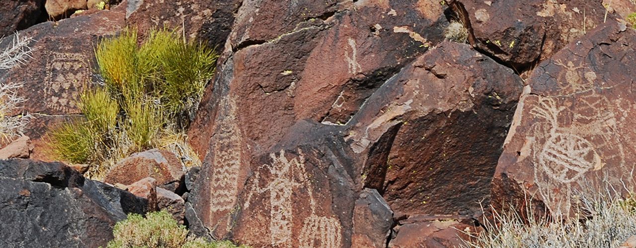
What is the difference between a petroglyph and a pictograph?
A petroglyph is made by cutting into the rock surface (“glyph” means “carving”). A pictograph is painted with a paint or dry pigment.
Are there any pictographs?
Yes, there are a few, in sheltered locations where the pigment has been preserved. There are three in Little Petroglyph Canyon, in the slot canyon above the old sheep corral area.
How are petroglyphs made?
Petroglyphs are made by removing the dark outer layer of the rock varnish, exposing the lighter rock beneath. The removal is done by pecking, abrading, scratching, or incising. The first three are frequently found in the Cosos; incising is rarely found because the basalt is too hard (it is often found in the southwest, on softer surfaces such as sandstone or limestone).
What is desert varnish and how does it occur?
Desert varnish (also called “rock varnish” or “patina”) is a dark coating which is primarily manganese. It is still the subject of study and is not fully understood, but the most likely explanation is that it is caused by microscopic bacteria which consume the dust from the atmosphere and leave a manganese residue. Small amounts of water enhance the process, but too much water will wash it away.
How have the petroglyphs been dated?
Two types of methods are used, qualitative and technical. Qualitative methods include analysis of superimposition of images, image content, and rock art context. Superimposition indicates which glyph was made first, but does not give actual dates. Content is more useful; for example, since the bow and arrow was introduced about 1,600 – 2000 yeas ago, any image showing a bow and arrow cannot predate that time. (The converse argument cannot be applied to the atlatl images, because it is not known whether the atlatl was fully supplanted.) Some rock art sites can be dated by context, usually the occurrence of other dateable archaeological artifacts. Technical methods which have been attempted include radiocarbon
measurements of microorganisms in the rock varnish, cation-ratio dating of the varnish, varnish microlamination, and X-ray fluorescence. Radiocarbon techniques have been discredited in this application, and are no longer used. The cation-ratio technique is still used on occasion, but different researchers get widely different results, so it is not generally accepted. Varnish microlamination has claimed good results but it is tedious and not widely used. X-ray fluorescence is a new technique and is still experimental, so its value cannot be assessed as yet. Attempts to date petroglyphs by the “freshness” of the carved surface have not been successful. In general, accuracies in dating rock art are poor; assigning a rock art panel to an archaeological period it is considered adequate.
Are there petroglyphs in areas other than Little Petroglyph Canyon?
Petroglyphs are found in abundance in the American Southwest, in other parts of North and South America, and throughout the world.
Why are some rocks covered with petroglyphs, while others have none?
Some seem to have been chosen for their public nature, others for their accessibility, and still others for proximity to village sites, trails, or springs. In general, however, it is not known how the ancient artists selected their panels.
Some petroglyphs are in very inaccessible places. Did the makers use ropes or ladders?
Ladders were known in the southwest, but have never been discovered here in the western Great Basin. The Shoshonean peoples made excellent cordage, and may well have had ropes. It is also possible that the floor of the canyon has filled in with sand or washed out in places.
How long would it take to make a petroglyph?
A simple, fairly shallow image can be created in a few hours. Some are very deeply pecked, which would have required days, possibly over the course of repeated visits to the site.
Some of the petroglyphs near the bottom of the canyon appear to be relatively primitive. Could these have been made by children?
It is certainly possible. People had to learn somehow.
Why are there so many images of bighorn sheep? There are several theories about this. One theory, based on interpretation of ethnographic accounts, is that sheep were carved to commemorate vision quests by shamans, as a part of rain-making rituals. A second theory is that the images were part of a cult related to hunting. There is archaeological evidence that fewer sheep were being hunted after about 1,500 years ago than earlier, suggesting that they had been hunted nearly to extinction; the cult is seen as an attempt to increase the numbers of sheep. A third view, also based on ethnography, is that the bighorn sheep was regarded as a benevolent “doctor” who provided for the needs of the people. There may be other explanations as well.
Are there bighorn sheep in the Cosos today?
Sheep were numerous in early historical times. In recent years they have been reintroduced into certain areas by the California Department of Fish and Game.
Why is there so much rock art in one location?
It is not known why certain locations exhibit concentrations of rock art. It might have been a ceremonial location or a location with some other significance, but we cannot tell now.
Are there Pueblo designs in the Canyon?
Yes, there are at least two anthropomorphs in the canyon that resemble images from the Puebloan southwest, and the “bordered cross” is well known in Pueblo areas. The “bordered cross” is found as far south as southern Mexico, in the Maya area, where it is said to represent Venus, the evening star. There are also two anthropomorphs that resemble Fremont images from Utah.
What do the “dots” and “grid signs” mean?
The meaning of these signs is unknown.
Is there on-going research on the petroglyphs?
Yes, both academic and contract-based research is ongoing, in the fields of archaeology and rock art studies. Articles are published in professional journals
such as American Antiquity, Journal of California and Great Basin Anthropology, and American Indian Rock Art.